|
The Railway Magazine Article September 1951
The Ouse Valley
Railway
By Michael Robbins
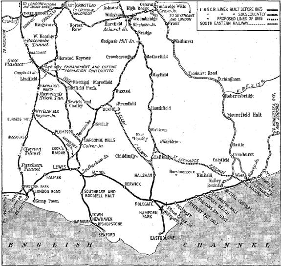
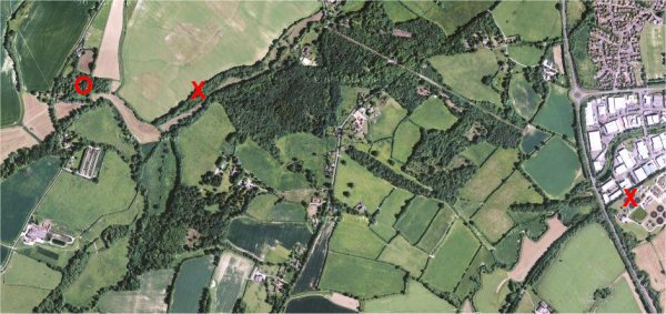
Map of East Sussex showing the Ouse Valley Railway and the St. Leonards
Railway in relation to existing lines.
In the middle years
of the 1860s, there was a wave of speculation in railways and promotion of
new lines that recalled, if it did not quite rival, the better known “mania”
of 1845 and 1846. As in the ‘forties, the boom of the ‘sixties collapsed in
spectacular fashion, with the failure of the important banking house of
Overend & Gurney, in 1866. The aftermath of the financial crisis that
followed involved the London, Chatham & Dover, and the North British in
special investigations made by committees of shareholders, forced many of
the weaker companies to amalgamate with their neighbours, and made even the
strongest railways retrench their proposals for expending capital.
Many new projects,
some valuable in themselves, others conceivable only in the exhilarating
competition of a boom, were abandoned in 1866 and the next few years. Some
of these were carried out later ; the Surrey & Sussex Junction Railway, for
example, a line authorised in 1865 to run from Croydon to Groombridge,
reappeared in the ‘eighties as the Croydon & Oxted joint line and its
continuation. Others were never begun; a few were partly built and then
abandoned, never to be carried through to completion. Of this last class
were the intended northern extremity of the Manchester & Milford Railway,
whose remains lie between Lianidloes and Liangurig, in Montgomeryshire, and
the subject of this article, the Ouse Valley (or Eastbourne Direct) Railway.
The history of this
line has been alluded to more than once in The Railway Magazine, most
recently in a note on a photograph by Mr. L. T. Catchpole, published in May,
1935 (vol. 76, page 373), and in an article “Abandoned Lines of the
L.B.S.C.R.,” by G. A. Sekon in November-December, 1946 (vol. 92, page 346).
The present notes bring together the historical references, and indicate
where the surviving physical evidences of the line are to be found. For a
half-finished work abandoned and overgrown for 85 years, there is a good
deal more to be seen than one might expect.
The Ouse Valley Railway, sanctioned by the London,
Brighton & South Coast Railway Act of June 23, 1864, was to run from the
Ouse Viaduct, between Balcombe and Haywards Heath, on the Brighton main
line, to Uckfield and Hailsham, with junctions at both places to existing or
proposed lines, as shown on the accompanying map. This railway, 20 miles
long, would have given the L.B.S.C.R. a line from London to Eastbourne a
mile or two shorter than the original and present route by Keymer Junction
and Lewes, but it still left it with a longer route to Hastings than the
South Eastern’s line via Sevenoaks (due to be opened in 1868) and Tunbridge
Wells. In the L.B.S.C.R. Act of May 26, 1865, therefore, the St.Leonards
Railway was authorised to continue the Ouse Valley line from near Hellingly
to St. Leonards, another 18 miles, through country that was both difficult
(for Sussex) and unremunerative.
Both these schemes were undertaken less on their own
merits than as moves in the complicated manoeuvres of the long battle for
railway control of East Sussex. It was fought between the Brighton and South
Eastern Companies, and for a short time even the London, Chatham & Dover was
involved by its joint participation in the London, Lewes & Brighton scheme
of 1866. The Surrey & Sussex Junction Railway, already mentioned, was
another promotion of this period, undertaken less for the sake of what it
could do for its owners than in order to spoil another railway’s chance of
getting into the territory it was to run through.
By 1868, however, the railway scene was changed; the
Brighton proprietors were very reasonably scared about their capital
commitments, and the Ouse Valley and St. Leonards schemes were abandoned by
Act of that year. In February, 1869, an agreement for pooling of traffic
between London and Hastings and other competitive points was made with the
South Eastern, and the Ouse Valley scheme, already dead, was buried. These
transactions are recorded in more detail by C. F. Dendy Marshall in the
“History of the Southern Railway,” and by G. A. Sekon in the article already
referred to.
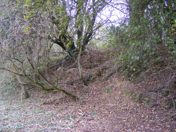
The Brighton’s repentance of its scheme did not come
early enough to prevent a contract being let, and some of the works being
carried forward to a fairly advanced state, both from the intended junction
with the main line, and for a shorter distance near Uckfield. The beginning
of the line lay between the south end of the Ouse Valley Viaduct and the
skew bridge over the lane leading from Balcombe to Haywards Heath by Borde
Hill; this bridge was to be widened and brickwork for extension of the
abutments on the east (down) side can still be seen. The next point where
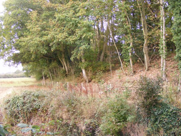
the Ouse Valley line can be traced is a tree covered embankment about 500
yd. south-east, close behind a red-tiled barn visible from the main line
near Copyhold Junction. The present branch line from Copyhold Junction
through Ardinigly to Horsted Keynes was not opened until 1883.
From this point the Ouse Valley works are continuous for
about two miles. An embankment, now covered with trees and undergrowth, runs
eastwards, turning gradually to the south-east. On both sides of the lane by
Copyhold Farm running up to Ardingly are brick abutments for a bridge. The
formation, tree-covered but still easily discernable then skirts the north
side of the Haywards Heath golf course and, after crossing High Beech Lane
(the road from Haywards Heath to Ardingly Station and College) just south of
Fountain Cottages, is lost for a short distance where the ground dips to the
west of Kenwards, an ancient building now used as a farm house. In front of
the house are two well-marked sections of cutting; the one to the east is
now filled with water. The springs here would have no doubt required
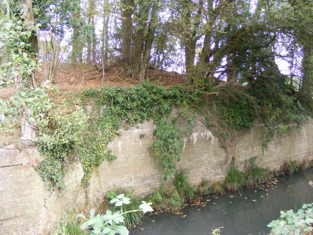
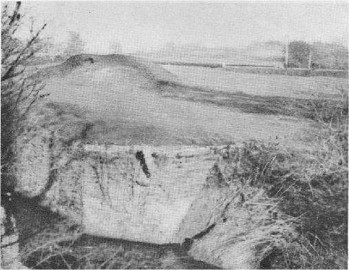
considerable drainage work had the line actually opened.. A prominent embankment, mostly covered with trees,
continues across the next depression of the ground, is lost, and then
reappears on both sides of the road from Haywards Heath by Lindfield and Ardingly to Turner’s Hill (B.2028), just north of Lindfield village, between
the church and a bridge over the Ouse. The remains of a brick abutment can
be seen on the west side of the road, about half-way down the hill. The
embankment continues for a few more yards, on the north side of a wooded
enclosure that marks the land purchased to lay out Lindfield station, and then comes to an
abrupt end a little north west of a house called
Hangman’s Acre.
Although a look at a good maps shows where land was
purchased and presumably enclosed work proper was probably never begun from this point almost as
far as Uckfield - certainly no above ground traces can be seen; but those who are
inclined to pursue their walk in that direction can discern here and there
the remains of an earlier, and long defunct, transport undertaking. The
River Ouse Navigation. Established under an act of 1790 this improved the river,
already used for barge traffic, by building locks up to Lindfield; traces of
the first of these can be found between Dean’s Mill, close to where the
railway works end, and Paxhill Park, north of the river.
Near Sheffield Park Station, the East Grinstead and Lewes
line, opened in 1882, crosses the intended route of the Ouse Valley line.
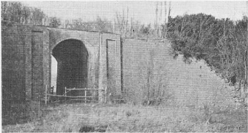
Further still from the IJckfield end, an embankment may be seen diverging to the west from
the line to Lewes about mile from Uckfield Station. Abutments for a bridge
over a stream lie close to the junction point, and there is a brick
underbridge a little further on. (Both these were illustrated on page 365 of
The Railway Magazine for November-December, 1946). The works continue across
the Uckfield - Isfield road, and come to an end in Darvel Wood, west of the
road, pointing towards Sheffield Park.
Such, briefly described, are the visible traces of a
project that the Brighton Company undertook in a spirit of optimism and
relinquished without regret. The reason for the existence of these curious
earthworks is more than half forgotten locally; on the 1 in. Ordnance Survey
map they do not appear at all. They are, however, well indicated on the new
1: 25,000 sheets, with the western most portion inscribed “Abandoned
Railway”; it would, perhaps be more accurate to write “Intended Railway.”
After another 85 years, these remains may look little changed from what they
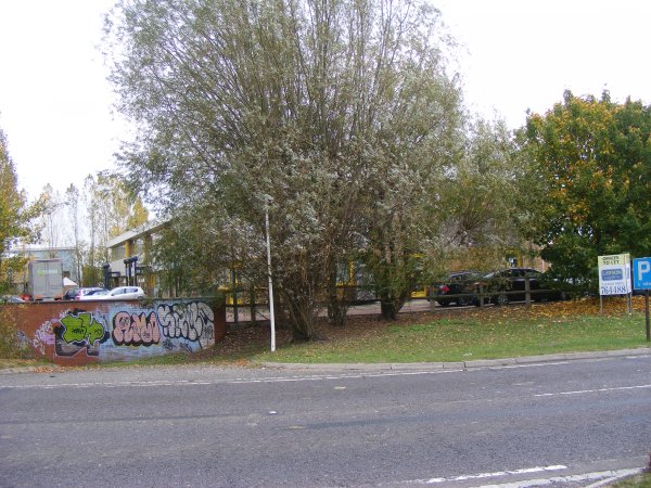
are today but I hope this web site will record what is there now.
|