|
A PICTORIAL GUIDE TO THIS MYSTERIOUS
RAIL LINE
The Ouse Valley Line was started but never
finished, some of it is still visible but disappearing fast! |
|
PAGE ONE - THE WESTERN END OF THE LINE |
|
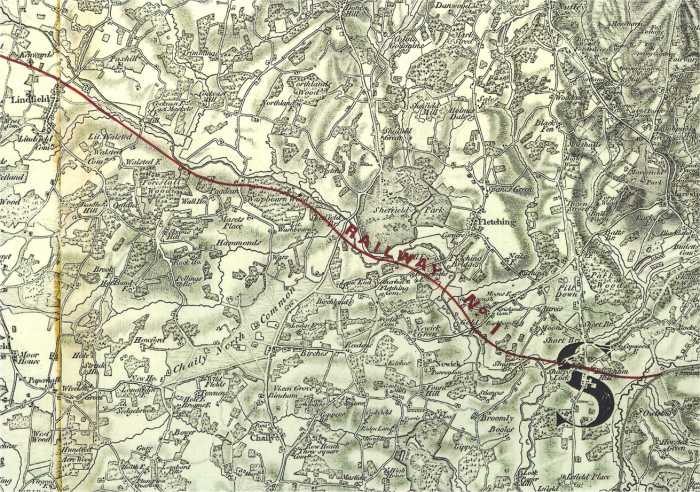
Map showing the planned route of the Ouse Valley Railway taken from the first document
deposited in Parliament in 1863. There were alterations made (but
obviously never built) which resulted from problems buying land at a
reasonable price and from levels
found in later surveys.
Click the map to download in a larger size. |
On the LBSCR, London, Brighton & South Coast Railway network
the least known line is the mysterious Ouse Valley Railway (also known as the
Ouse Valley Line) - started yet never finished. No trains proper ever ran along
its 20 miles of lines yet some say they can still hear the loco whistle! This
railway line was supposed to run from a new junction with the London to Brighton
line through Lindfield and then on to Sheffield Park and ultimately Uckfield in
Sussex. There were even plans for the line to continue to Hastings. Had the
"Ouse Valley Line" been finished it is almost certain that the East Grinstead to
Lewes line (which of course became "The Bluebell Railway") would have never been
built. Construction stopped abruptly after floods and financial problems delayed work in February
1867 and the landscape has remained virtually unchanged ever since. Even so, the few
traces that still exist some 135 years later are rapidly returning to nature so
we show here some photos of the line taken at various times from January 2003 to
date. How much of this
will still be there in another 100 years? Very little is our guess! Any photo
on this page MAY be
published as long as due acknowledgement is made to the copyright holder - horstedkeynes.com. As another exception to the rest of this web site the
pictures here are little compressed to show as much detail as possible, this page
will therefore take some considerable time to load over a slow connection.
Excellent quality 1947 aerial photographs of the Western
end of the line can be found
here and
here. Unfortunately the flight did not quite cover the very eastern end of the route
near Uckfield, but the rest of the line can be found. Photographs come from Sussex University archive.
Authorisation for the building of the "Ouse Valley Line" was
given in 1864, the enabling act being [(c.cxxxv),
s.25; L.B. & S.C.R.(Ouse Valley Line) 1864 (c.cxxiii),] The line was to
start at a new junction with the existing London to Brighton line
immediately South of the Ouse Valley viaduct. At the first over bridge just by
here you can see two wide walls which were built to hold a new over bridge next
to the bridge in the distance which carries the main London to Brighton line.
These are very substantial as they supported a temporary wooden bridge
during the construction of the line. Surprisingly although the bridge is within
a few feet of the junction, the temporary wooden structure never
carried any connected running rails as the spoil from the building of the tunnel along the line
never quite reached here. Construction actually stated at a point a mile or so
away to the East towards what is now Haywards Heath Golf Club. This was a common
method of building railways in those days. Where you or I would start at one end
and then build away from an existing railway, they would start and build a camp
where the most spoil was available and work out from there. This explains why
the earthworks shown below do not always connect to each other. A contractor's
locomotive would be manhandled to this point and would transport the earth to
where it was needed using a temporary line. This explains why the rails
on regular railways are often referred to as the permanent way - now you
know!
The Ouse Valley Railway was built for a unique reason.
Not like all other railways to transport passengers or goods from a to b, but
instead the main reason was to
stop the London Brighton & South Coast Railway's competitors' from
getting a foothold in this part of rural Sussex! The idea was simple, start to
build a railway, but build it as slowly as Parliament would permit, and the
"opposition" would look elsewhere when deciding where to build their next
railway! There were other legal reasons why once one Company had started to
build a line to serve an area then others would find it well nigh impossible to
get an Act serving the same area passed by Parliament.
It is perfectly true to say that had the Ouse Valley Railway
opened then the Lewes extension to the London and East Grinstead Railway would
have never been built. That became The Bluebell Railway! It is perhaps
interesting to note that whichever railway was built Sheffield Park would have
had a station in the same place, except going from West to East in the Ouse
Valley plan, instead of North South as at present.
What you see on the ground is
really a work in progress. When the railway was abandoned it was left as it was,
nothing was tidied up. In other words it was common to get the embankments up to
a level where temporary rails could be laid so that spoil could be transported
from one work site to the other, and then tidy the whole thing up later. There
are for example holes in the ground (now full of water or buried under thick
vegetation) that would no doubt have been filled in later. Some of the
embankments were no doubt to be widened once more spoil was available from work
elsewhere. This also helps explain why some of the cuttings seem wider than
needed, together with the fact that the soil in this area was quite unstable
making the slopes less steep than on other railway lines.
The Ouse Valley Railway was being built in a fairly direct
line linking the London to Brighton line with Uckfield. The route would have
taken the line via the already built embankments to Lindfield, then just north
of Great Walsted Farm, south of the Sloop Inn, then through Waspbourne Wood,
south of Sheffield Bridge (through where Sheffield Park station now lies). After
this it would have gone north of Nether Hall, just south of Colstrow Farm (which
would have either had the trains running within a few feet of the front door or
would have had to be demolished), through Shortbridge, and then rejoining the
existing route to Uckfield.
Because the route followed closely the line of the river Ouse
the finished line levels were bearable but still in a couple of places heavy
earthworks were needed. There were three places where deep cuttings might have
been made as tunnels. Under Buckham Hill where the railway was 63 feet (20
Metres) below the level of the road, at Nether Hall, and almost certainly at
Kenwards where the line would have been 50 feet (15 Metres) below the adjacent
road. (Future dimensions will be shown like this, feet and inches, 26'
9".)
The entire route was thoroughly surveyed for the Act of
Parliament, the plans are still in existence and available to view at the East
Sussex Records Office.
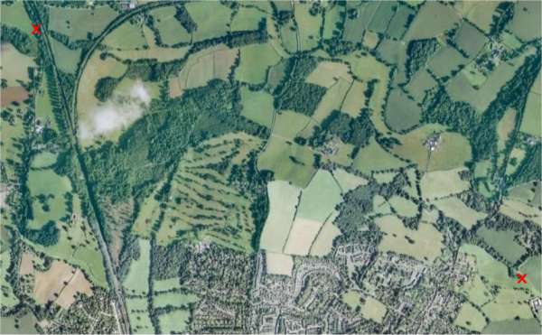
The Western end of the line runs in a very gentle curve just
under two miles long between the two red Xs. The left most X is on the main
London to Brighton railway line and the smooth curve is the remains of the line
linking Horsted Keynes and Ardingly with Haywards Heath. The houses at the bottom of the
picture are Lindfield near Haywards Heath, Sussex. Haywards Heath Golf
Course can be clearly seen lying to the South of the route.
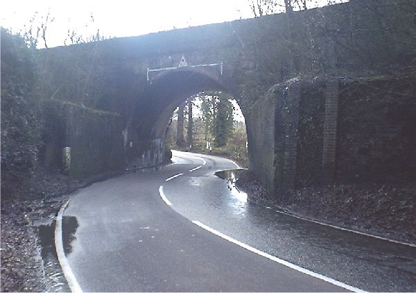
The Skew Bridge where the Ouse Valley Railway deviates from
the London to Brighton main line. From here our railway travelled over some quite serious
earthworks now hidden in thick woods, some of the spoil came from the earthworks
at Kenwards Farm. Other came from natural deposits in the area of the golf
course. Despite visiting in the depth of winter when vegetation was low we
were unable to take any meaningful pictures here although the course of the line
could be walked by a determined investigator (with the landowners permission of
course). The earthworks are at least 60 feet high in places and are just as
intrusive as those on the main London - Brighton line built some 30 years
before, so great care would be needed. If we do manage to find a clear spot for
photography then pictures will certainly appear here in due course. Some of
these earthworks around here are in parallel "layers" going across the course of
the railway about 3 feet apart. We would love to know why this was, or what
process caused these striations. Perhaps the last remains of some prehistoric
steam earthmover?
The photo above is near the end of the first of these
earthworks where the line crossed a lane by substantial skew over bridge the
remains of which are shown below. As you can see some of the spoil for these
mounds came from the hole in the ground now filled by water! There are still brick courses to be seen
about here
built to hold back the embankment at the site of the new bridge which remained
as an obstacle to traffic on the narrow lane for many years until being demolished
by local land owners in
the last years of the 19th Century.
The above photo is somewhat misleading as it was taken half
way up and shows the second
embankment which is on top of a lower one, making the rail height about 20 to 25 feet (7
or 8 metres) above present day road level. This indicates that the dismantled
bridge may have been a three arch affair.
After this bridge there are yet greater earthworks where the
line curves gently around what is now the Haywards Heath Golf Course.
Despite trying for hours to find a place to photograph these earthworks because
of the heavy wood cover here the remains
just don't show on a photo, we are still looking. The strange striations mentioned above
are at their most apparent here.
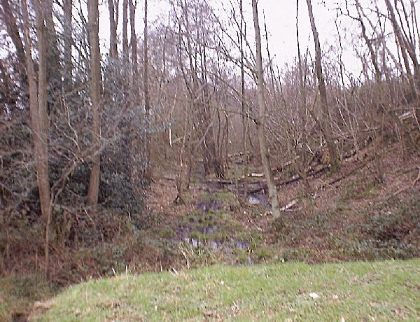
The line then enters the start
of a fairly short but deep cutting into where a tunnel would have been built which
we shall call "Kenwards Farm Tunnel" after the farm near where it would have
emerged. According to the deposited plans the rail level of this tunnel would have been 26' 9" below the Ardingly road.
|
 |
 |
(Left) Looking back from where we have come a very(!) rough idea of how the land might have looked
once the tunnel was built. The straight tunnel, perhaps 150' long, is in the FAR hillside
and the photo would have been taken from a mythical underbridge some 50'
above rail level and a few feet from the front door of Kenward's Farm! |
|
The trees in the centre of the pictures above show the brow where
the Eastern end of "Kenwards Farm Tunnel" would have emerged, just below where
the lane meets the trees. The land in the foreground would have been cut away to
a depth of perhaps 60' or more continuining the existing cutting shown
below, and the line would have been at the bottom of
the dip in the lane. Kenwards Farm is to the immediate Right of this picture and
their road would have been right at the edge of the cutting.
(Picture taken with permission of land owner)
We are now looking in the opposite direction from the last
picture beside Kenwards Farm itself which would have been
left on the edge of a deep cutting had construction continued for just a few
more weeks. This would have severely altered the grounds of this beautiful
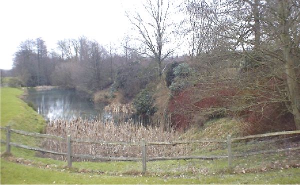
Sussex farmhouse. Fortunately excavations just by the farm were not started and
the part of the cutting that had been built nearest the house has been dammed
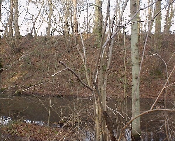
and turned into a lake. Shown above is the lake taken from Kenwards looking East
which shows the depth of the earthworks these would of course have been at the
depth of the bottom of this lake! (Picture taken with permission of
land owner)
The cutting itself taken in poor light but still showing the
depth of the cutting below the lake at Kenwards. The embankment on the right,
Southern, side is perhaps 60 feet or more high. (Picture taken with permission of
land owner)
Below is a picture showing how the Kenwards Farm area looked
before the flooding for the lake. Air photo taken just after the Second World
War in April 1947. Click the photo to take the full size download from the
University of Sussex.
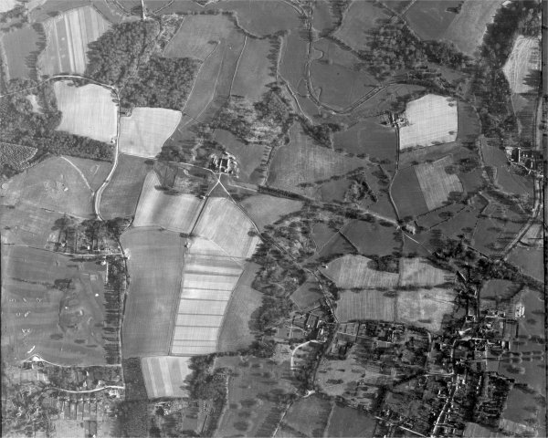
There are many other 1947 air pictures from the area shown
at the following link (the indexing is unfortunately a bit hard to follow - zoom
in and then out again to trigger the Java indexing.) Each photo is about 1Meg in
size.
http://www.geog.sussex.ac.uk/grc/info/airphotos-historic/indexing/index.html
Some two to three miles from where the railway deviated from the
main London-Brighton Line junction
we are now approaching the site of Lindfield Station where the line would have
crossed the London turnpike on a bridge 36' wide and 16' high. Just before we get there however there is the site
of another set of earthworks each side of Spring Lane. The first picture shown
below is to the West and the second is on the East side of where a small
occupation bridge was built to serve Spring Lane. The main point of interest is
that the earthworks come to an abrupt stop in the middle of a field! Again the
earthworks are quite substantial and would have been built from the spoil gained
from the cutting at the entrance to the proposed tunnel under Kenwards Farm.
Further extension of the earthworks would have had to await the construction of
Kenwards Farm tunnel itself which of course never happened. It is interesting
that despite almost a century and a half having passed only the bridge has
disappeared, none of the soil has been removed to build up nearby fields as the
earthworks must get in the way of farm operations.
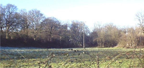
West of Spring Lane taken from the North side the embankment in the distance
follows the tree line parallel to the electricity lines.
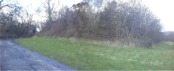
The odd clump of earth to the East side of Spring Lane which just stops right
in the middle of a field!
The height here is between 15' and 20' (5 to 6 metres). A bridge would have
been built on the left hand edge of the above photo where the small vertical
tree is located.
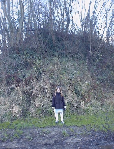
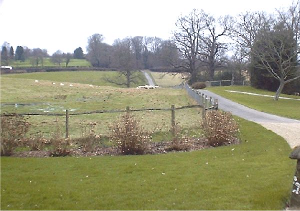
A feeling of scale is shown here at the site of
the over bridge to the left of the above picture.
The line was obviously built for single track working here.
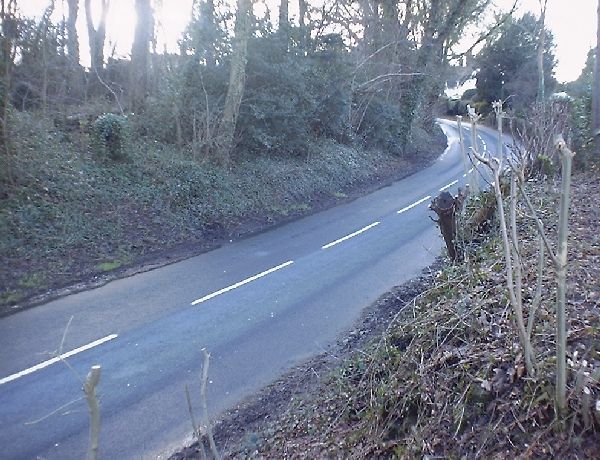
Just how much greenery would still be visible had a station been
built beside this road is anyone's guess! The line would have crossed in the
foreground of this picture where a bridge caused traffic congestion for some
years. The thick tree stump on the centre right foreground is now supporting
some of the old brickwork shown below. To the left the earthworks just stop
again after a few dozen yards where a bridge would probably have crossed
the river Ouse (not for the only time we would guess!) Interestingly the
earthworks here are much wider suggesting quite obviously a double track layout for Lindfield
station which would have been on the Eastern side of the turnpike near Dean's
Mill where a plot of land had been purchased.
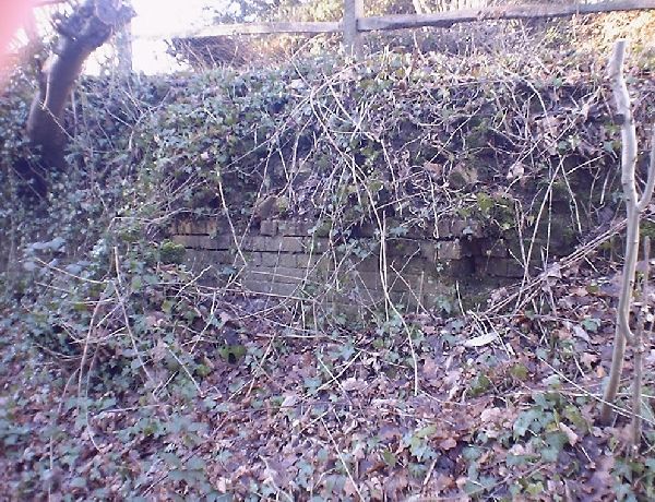
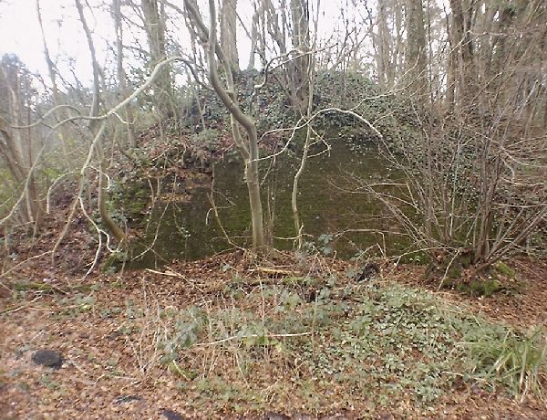
The same trees stump on the top left of the picture above at
the proposed site of Lindfield station helps hold back some brickwork of the
demolished Lindfield over bridge which was built with a 36' span. The remaining
brickwork on the other side of the road above (actually the Eastern side) was
removed many years ago to ease a dangerous curve on the steep hill. The bricks
from here hold up many of the borders in nearby gardens!
It had been thought that this was the end of the railway
remains but recent studies of internet maps show that the embankment Nothing
else of this strange line is visible until the we approach Uckfield some 5 miles
further on. And if you think that isn't far then this railway would have taken a
very direct route.
We have carefully compared a map of the route with Google
Earth and can see no groundworks on the intervening line. This is hardly
surprising as the men would have worked from where they had easy access, i.e.
where an existing railway connection was available.
ON TO PAGE TWO OF THIS FEATURE
|


