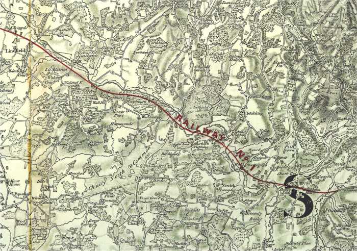
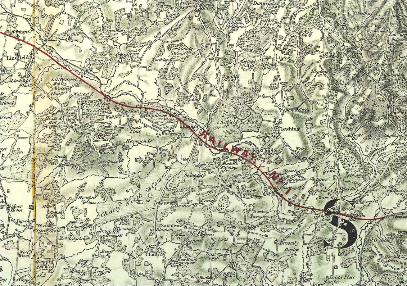
Sussex view. Updated every few minutes. Dark at Night!
Our other live cameras


HOW TO FIND US
Index to our site
Village Road Map
Local weather report
6 Sussex webcams

PLACES TO VISIT
The Bluebell Railway
Two and a half pubs
More local attractions
Local web sites


IF YOU LIVE HERE

Local information
Local computer help
What's happening?
Council Minutes
Situations Vacant
Please slow down
Bonfires
Rubbish
Power Cut Misery
Free local ads

IF YOU WANT TO LIVE HERE!
Property for sale

HISTORY
Photos old and new
Old  Maps
Historical scrapbook
Village Memories
How it was in '86
School history
Church history
The Martindale Centre
Family history search

Ouse Valley Railway
Freshfield Action Grp.
Our French twin

PLACES TO STAY
Local accommodation
Add your establishment here

OTHER PAGES
Filming news & Extras
Your own village email address
Your own local business web site

Your family web site

BBC Southern Ways

Wireless HotSpot


The HorstedKeynes.Com recommended UK based ISP


  YOU ARE IN: OUSEVALLEY
A PICTORIAL GUIDE TO THIS MYSTERIOUS RAIL LINE
The Ouse Valley Line was started but never finished, some of it is still visible but disappearing fast!

This page uses high quality graphics and may take a considerable time to load on a slow connection.

The Ouse Valley Railway was built for a unique reason. Not like all other railways to transport passengers or goods from a to b, but instead to stop the London Brighton & South Coast Railway's competitors' from getting a foothold in this part of rural Sussex! The idea was simple, start to build a railway, but build it as slowly as Parliament would permit, and the "opposition" would look elsewhere when deciding where to build their next railway! There were other legal reasons why once one Company had started to build a line to serve an area then others would find it well nigh impossible to get an Act serving the same area passed by Parliament.

It is perfectly true to say that had the Ouse Valley Railway opened then the Lewes extension to the London and East Grinstead Railway would have never been built. That became The Bluebell Railway!

Can we also point out that what you see on the ground is really a work in progress. When the railway was abandoned it was left as is, nothing was tidied up. In other words it was common to get the embankments up to a level where temporary rails could be laid so that spoil could be transported from one work site to the other, and then tidy the whole thing up later. There are for example holes in the ground (now full of water or buried under thick vegetation) that would no doubt have been filled in later. Some of the embankments were no doubt to be widened once more spoil was available from work elsewhere. This also helps explain why some of the cuttings seem wider than needed, together with the fact that the soil in this area was quite unstable making the slopes less steep than in other areas.


The Western end of the line runs in a very gentle curve just under two miles long between the two red Xs. The roads at the bottom of the picture are Lindfield near Haywards Heath, Sussex, and Haywards Heath Golf Course can be clearly seen to the South of the route.

On the LBSCR, London, Brighton & South Coast Railway network the least known line is the mysterious Ouse Valley Railway (also known as the Ouse Valley Line) - started yet never finished. No trains proper ever ran along its 20 miles of lines yet some say they can still hear the loco whistle! This railway line was supposed to run from a new junction with the London to Brighton line through Lindfield and then on to Sheffield Park and ultimately Uckfield in Sussex. There were even plans for the line to continue to Hastings. Had the "Ouse Valley Line" been finished it is almost certain that the East Grinstead to Lewes line (which of course became "The Bluebell Railway") would have never been built. Construction stopped abruptly after floods had delayed work in February 1867 and the landscape has remained virtually unchanged ever since. Even so, the few traces that still exist some 135 years later are rapidly returning to nature so we show here some photos of the line taken in January 2003. How much of this will still be there in another 100 years? Very little is our guess! Any photo on this page MAY be published as long as due acknowledgement is made to the copyright holder - horstedkeynes.com. As another exception to the rest of this web site the pictures here are little compressed to show as much detail as possible, this page will therefore take some considerable time to load over a slow connection.


Excellent quality 1947 aerial photographs of the Western end of the line can be found here and here. Unfortunately the flight did not cover the Eastern end of the route near Uckfield. Photographs come from Sussex University archive.


Authorisation for the building of the "Ouse Valley Line" was given in 1864, the enabling act being [(c.cxxxv), s.25; L.B. & S.C.R.(Ouse Valley Line) 1864 (c.cxxiii),] The line was to start at a new junction with the existing London to Brighton line immediately South of the Ouse Valley viaduct. At the first over bridge just by here you can see two wide walls which were built to hold a new over bridge next to the bridge in the distance which carries the main London to Brighton line. These are very substantial as they supported a temporary wooden bridge during the construction of the line. Surprisingly although the bridge is within a few feet of the junction, the temporary wooden structure never carried any connected running rails as the spoil from the building of the tunnel along the line never quite reached here. Construction actually stated at a point a mile or so away to the East towards what is now Haywards Heath Golf Club. This was a common method of building railways in those days. Where you or I would start at one end and then build away from an existing railway, they would start and build a camp where the most spoil was available and work out from there. This explains why the earthworks shown below do not always connect to each other. A contractor's locomotive would be manhandled to this point and would transport the earth to where it was needed using a temporary line. This explains why the rails on regular railways are often referred to as the permanent way - now you know!

The wide butresses at the side of the London to Brighton LBSCR.

From here the line travelled over some quite serious earthworks now hidden in thick woods, some of the spoil came from the earthworks at Kenwards Farm. Other came from natural deposits in the area of the golf course. Despite visiting in the depth of winter we were unable to take any meaningful pictures here although the course of the line could be walked by a determined investigator (with the landowners permission of course). The earthworks are at least 60 feet high in places and are just as intrusive as those on the main London - Brighton line built some 30 years before, so great care would be needed. If we do manage to find a clear spot for photography then pictures will certainly appear here in due course. Some of these earthworks around here are in parallel "layers" going across the course of the railway about 3 feet apart. We would love to know why this was, or what process caused these striations. Perhaps the last remains of some prehistoric steam earthmover?

An embankement to the West

The photo above is near the end of the first of these earthworks where the line crossed a lane by substantial skew over bridge the remains of which are shown below. As you can see some of the spoil for these mounds came from the hole in the ground now filled by water! There are still brick courses to be seen here built to hold back the embankment at the site of the new bridge which remained as an obstacle to traffic on the lane for many years until being demolished in the last years of the 19th Century.

The site of the second overbridge.

The above photo is somewhat misleading as this is the second embankment on top of a lower one making the rail height about 20 to 25 feet (7 or 8 metres) above present day road level.

After this bridge there are yet greater earthworks where the line curves gently around what is now the Haywards Heath Golf Course. Despite trying for hours to find a place to photograph these earthworks because of the heavy wood cover here the remains just don't show on a photo, we are still looking. The strange sttriations mentioned above are at their most apparent here.

The line then enters the start of a very short but deep cutting into where a tunnel would have been built which we shall call "Kenwards Farm Tunnel" after the farm near where it would have emerged.

(Left) Looking back from where we have come a VERY rough idea of how the land might have looked had the tunnel been built. The straight tunnel, perhaps 60 feet long, is in the FAR hillside and the photo would have been taken from a mythical underbridge some 50 feet above rail level and a few feet from the front door of Kenward's Farm!

The trees in the centre of the pictures above show the brow where the Eastern end of "Kenwards Farm Tunnel" would have emerged, just below where the lane meets the trees. The land in the foreground would have been cut away to a depth of perhaps 80 feet or more continuining the existing cutting shown below, and the line would have been at the bottom of the dip in the lane. Kenwards is to the immediate Right of this picture and their road would have been right at the edge of the cutting.
(Picture taken with permission of land owner)

Kenwards Lake

We are now looking in the opposite direction from thhe last picture beside Kenwards Farm itself which would have been left on the edge of a deep cutting had construction continued for just a few more weeks. This would have severely altered the grounds of this beautiful Sussex farmhouse. Fortunately excavations just by the farm were not started and the part of the cutting that had been built nearest the house has been dammed and turned into a lake. Shown above is the lake taken from Kenwards looking East which shows the depth of the earthworks these would of course have been at the depth of the bottom of this lake! (Picture taken with permission of land owner)

Kenwards Cutting

The cutting itself taken in poor light but still showing the depth of the cutting below the lake at Kenwards. The embankment on the right, Southern, side is perhaps 60 feet or more high. (Picture taken with permission of land owner)

Some three miles from the London-Brighton Main Line junction we are now approaching the site of Lindfield Station where the line would have crossed the London turnpike. Just before we get there however there is the site of another set of earthworks each side of Spring Lane. The first picture shown below is to the West and the second is on the East side of where a small occupation bridge was built to serve Spring Lane. The main point of interest is that the earthworks come to an abrupt stop in the middle of a field! Again the earthworks are quite substantial and would have been built from the spoil gained from the cutting at the entrance to the proposed tunnel under Kenwards Farm. Further extension of the earthworks would have had to await the construction of Kenwards Farm tunnel itself which of course never happened. It is interesting that despite almost a century and a half having passed only the bridge has disappeared, none of the soil has been removed to build up nearby fields as the earthworks must get in the way of farm operations.

Ouse Farm Embankement

West of Spring Lane taken from the North side the embankment in the distance follows the tree line parallel to the electricity lines.

An odd clump in a field

The odd clump of earth to the East side of Spring Lane which just stops right in the middle of a field!
The height here is between 15 and 20 feet (5 and 6 metres). A bridge would have been built on the left hand edge of the above photo where the small vertical tree is located..

A feeling of scale A feeling of scale is shown here at the site of
the over bridge to the left of the above picture.
The line was apparently built for single track working here.

The site of Lindfield Bridge and Station

Just how much green would still be visible had a station been built beside this road is anyone's guess! The line would have crossed in the foreground of this picture where a bridge caused traffic congestion for some years. The thick tree stump on the centre right foreground is now supporting some of the old brickwork shown below. To the left the earthworks just stop again after a few dozen yards  where a bridge would probably have crossed the river Ouse (not for the only time we would guess!) Interestingly the earthworks here are much wider suggesting a double track layout for Lindfield station which would have been on the Eastern side of the turnpike near Dean's Mill where a plot of land had been purchased.

Old brickwork

The same trees stump on the top left of the picture above at the proposed site of Lindfield station helps hold back some brickwork of the demolished Lindfield over bridge. The remaining brickwork on the other side of the road above (actually the Eastern side) was removed many years ago to ease a dangerous curve on the steep hill. The bricks from here hold up many of the borders in nearby gardens! Nothing else of this strange line is visible until the we approach Uckfield more than 12 miles distant.


Now to the other end of the line at Uckfield.

Our first picture of the Eastern end shows an overhead view of the substantial earthworks that are still in situ. They stretch in a smooth arc between the two red Xs. Interestingly the length of the earthworks is almost to the inch exactly one mile! Whether a contractor was hired to dig for exactly this length and they stopped as soon as possible I don't know but it is an interesting fact none the less. The part of the earthworks to the Western end in the thick wood are a deep cutting which is not easily seen from above. After careful consideration we have decided to ignore the ploughed field where two white "blobs" are visible. Although just to the side of the intended route it is possible that some earthworks were originally here but have been filled in.

A further set of pictures of the ground features of the "other" end of the line near Uckfield will appear here soon but in the mean time if you have any questions about the railways around Horsted Keynes please do get in touch by emailing the webmaster.

A recently made home video lasting well over one hour and showing all the remains of this line can be obtained from www.dumpman.co.uk. Whilst this is very interesting and is recommended we would suggest that if you want to avoid nausea you only watch in short spells as the film maker does not seem to possess a tripod which means that the pictures are very shaky indeed. Pity as he is happy to go where others fear to tread!


© June 2009  All exclusive content on this web site (including photographs) is copyright and may not be published in any media or  reproduced on any other web page without express written permission. This will not be unreasonably withheld as long as you ask FIRST!
We are very unusual in allowing almost all pictures on H.K.Com to be viewed and downloaded in full resolution for PERSONAL use only. Just click on the picture that you want to study and it will open. If you then see a little + symbol left click again to view it full size.
To save the picture right click and then "Save As". You may NOT copy our pictures onto other web sites without specific permission.
You can contact the webmasters by sending an email to webmaster@horstedkeynes.com or ringing 791624.   Web Design by Chris Philpot