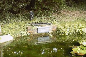
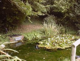
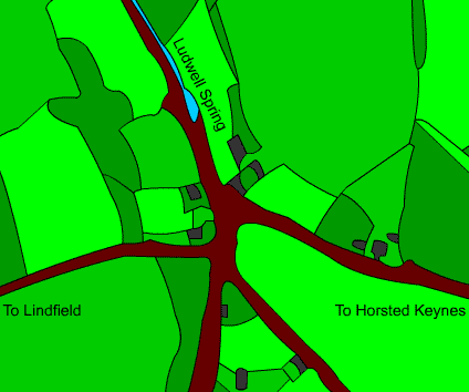
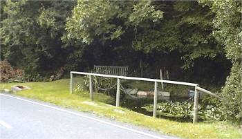
|
HORSTED KEYNES IN
THE PAST
By S. L. NEWNHAM (a Native)
An article from The Mid Sussex Times Tuesday April
18th., 1922
Horsted
Keynes at the time of the Conquest was probably a somewhat important
place, as according to "Doomsday" there were four Hides (which were
probably enclosed) and also land for eight ploughs. On the demesne were
also nine villains, with three ploughs, a mill yielding two shillings,
and three borders. In the time of King Edward Horstede was worth sixty
shillings, while Bontegrave (Bunch or Birch Grove) had only land for
half a plough and was worth but two shillings. A hide was probably about
120 acres, and the land for a plough about the same extent. There was a
considerable quantity of land enclosed or under cultivation.
Probably
the place was much larger than at the present time, for besides the main
road through the village there were two back lanes, one leading to the
church from two directions and the other leading from the bottom of the
Green to Camomile Cross. There were also the Berrin Hill (burying hill),
Bonfire Lane, Seritnpet (pit) Lane, Slough Lane, and Boxes Lane, also
the roads heading from the bottom of the village towards Treemans, and
that going from Agnes Cross towards Treemans, the whole forming quite a
network of communications.
At the time
of Doomsday Horsted was only worth forty shillings, instead of sixty,
which shows that much damage was done by the Normans. Probably the
village was destroyed, and has never recovered to its former state. Some
of the lanes mentioned were enclosed under Inclosure Award. This was an
ideal spot for a large village in those days as the land is a dry sandy
soil.
The
meaning of the first part of the word Horsted is doubtful, but there
might have been a number of horses kept on the enclosed land. The word "stede"
means "settled habitation" (Cooper). The parish is called "Horstede" in
"Doomsday".
At the
time of "Doomsday" William de Cahaignes held Horstede, and from him it
takes it suffix of "Keynes". The name in times past has been spelt "Kahains",
"Kaines", "Kaynes", but is now "Keynes".
Horsted
cannot boast of many ancient buildings, but there is a fine old church.
Broadhurst, after having been occupied by the Cahaignes, Chaloners,
Michelbournes, Lightmakers and Piggots, has come to grief. A large
portion of the grand old manor house having been taken down and only a
small portion remaining for a farmhouse.
The only
old mansion remaining is Treemans, the residence of the ancient family
of Wyatt, who were here until the beginning of the nineteenth century.
It was afterwards used as a farmhouse until it was restored to its
former glory by the late Mr. Guy Hardy. For years this fine old mansion
was occupied by the late Mrs. Benson, widow of a former Archbishop of
Canterbury, and Miss Tate, a daughter of a former Primate.
A few years
ago Captain Lewes Wyatt, (a descendant of the Wyatt family) took up his
abode in Horsted Keynes, after being abroad on service for many years.
The family have been in all our wars from the Peninsular onwards. At the
outbreak of the late war Lieutenant Godfrey Louis Wyatt, the only son of
the Captain, true to the traditions of his family, obtained his
commission and died of wounds at the Dardanelles in 1915.
The
beautiful carving on the pulpit in the parish church is the handiwork of
Captain Wyatt, who says the word Treemans is taken from the Latin words
Tres Montes, meaning three hills. All three hills begin in Ashdown
Forrest, the first at Chelwood Gate, and then goes through Dane Hill,
passes near Treemans and ends in the Ouse valley. Treemans being
situated on the slopes of this hill. The third hill runs through
Ardingly and West Hoathly, passing near Treemans and ending in the Ouse
valley in the parish of Lindfield. All three reach an altitude of
between 600 and 700 feet above sea level.
Captain
Wyatt has a highly interesting old map of the Manor of Treemans, dated
1729 made for Richard Wyatt, Esquire. There is a drawing of the house
and buildings on it, and on the north side of the avenue leading to the
house there was a cherry garden over six acres in extent, this showing
the cherries must have been a favourite fruit in those days.
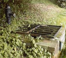
Small
barges used to run from Keysford to the Ouse. At this time Cockchase
mill stood between the brook and Grove Wood, and above this there was a
mill pond, a portion of the pond bay (dam) still remaining. As this pond
would interfere with the running of barges a canal was made on its east
side and a large portion of this is still to be seen. It is very evident
that the brook has been deepened to give a deeper draught to the boats,
also that a wharf was made a Keysford. The following is an extract from
a dictionary published in 1745 (a time when boats must have been on this
brook): ""kay" or "key", a wharf or place made fit for, or ordered to be
used as a place to land goods, certain rates, fees, or charges being
settled for that purpose."
The road
on the Lindfield side of the brook runs almost parallel with it, with a
space between to load or unload boats. It is the same at Cockchase (now
known as Cockhaise), only in this case the wharf was on the Horsted
Keynes side of the brook. In a dictionary published in 1775 one of the
meanings of the word "cock" is a small boat, and according to Cooper,
"case" is a British or Keltic road for river; so "Cockchaise" means
Small Boat River. There was also a wharf near the Weir Wood, and a road
is shown on the old map of Treemans leading to this wharf. Captain Wyatt
says this was a public road. A continuation of it is shown on the
Ordinance Map of 1875, but it is now only used as a public footpath.
There is
evidence showing that most probably the brook above Keysford has been
deepened and that boats (possibly smaller ones) went as far up as the
ironworks at the Cinder Bank, and may be chalk was conveyed to the same
place as there is a lane called Kell (Kiln) Lane. In this way guns could
be conveyed from the furnace to the coast, which according to Lower was
often done, and they were smuggled to foreign countries.
With the
aid of Captain Wyatt’s old map it is quite safe to say that boats
conveyed goods from at least Keysford to the river Ouse at least 200
years ago, and many years before the River Ouse was canalised. The
difficulties of level must have been overcome, as in normal times there
would not have been sufficient draught of water for barges to travel.
The altitude at Keysford is 125 feet, and at Cockchaise 93 feet, so in
less than a mile and a half there is a fall of 32 feet.
These
waterways in bygone days were very important, and in the rainy seasons
most of the roads were almost impassable. The following is from a book
published in 1761: "I have seen one tree on a carriage, which they call
a tug, drawn by 22 oxen; and even then it carried so little a way (being
thrown down and left for other tugs to take up and carry on) that
sometimes it is two or three years before it gets to Chatham: for if
once the rains begin. It stirs no more that year, and sometimes a whole
summer is not dry enough to make the roads passable."
Barges were
formerly built in the village, the yard being on the site of which is
now the Baptist Chapel and old wheelwright’s shop and cottages stand.
The pond was still there as late as 1843, and is shown on the
Tithe map
of the parish.
The river
Medway runs within one and a half miles of the northern boundary of the
parish of Horsted Keynes.
From
The Mid Sussex Times
May 1922
[n.b. (Webmaster's notes) Treemans is now
called Tremaines, Keysford is shown as Caresford on some older maps and
much of this area is now buried under the village water pumping works.] |